Contact: +91 99725 24322 |
Menu
Menu
Quick summary: Learn how to conduct a comprehensive deforestation risk assessment under EUDR. Understand the key steps, data sources, and best practices for ensuring compliance with the EU Deforestation Regulation. Safeguard your supply chain with actionable insights for deforestation-free sourcing and sustainability.

Under the EU Deforestation Regulation (EUDR), companies must prove that their products are not linked to deforestation occurring after December 31, 2020. This requirement makes deforestation risk assessment a core compliance step. Without it, operators cannot lawfully place goods like coffee, cocoa, soy, or rubber on the EU market.
Under the EU Deforestation Regulation (EUDR), exporters and operators must assess deforestation risk for each farm plot by verifying land-use change since 2020, checking proximity to protected areas, and scoring risk using satellite data and legal documents. Tools like Hansen GFC, Sentinel-2, and traceability platforms streamline the process and reduce compliance errors.
The consequences of missing or inaccurate assessments are serious: rejected shipments, financial penalties, or even bans from the EU. That’s why exporters, producer companies, and especially “first placers” (those introducing products into the EU) must implement robust, verifiable risk assessment methods—using satellite data, geolocation files, and documented land legality.
Key Takeaways
Discover how a leading tire company successfully future-proofed its rubber exports by navigating EUDR compliance. Learn how TraceX’s solutions streamlined their traceability processes, ensured deforestation-free sourcing, and kept them ahead of evolving regulations.
Read the full case study on how they achieved seamless EUDR compliance and transformed their supply chain for long-term sustainability.
A deforestation risk assessment under the EU Deforestation Regulation (EUDR – Regulation (EU) 2023/1115) is the process by which operators and traders evaluate whether a commodity was produced on land that experienced deforestation or forest degradation after 31 December 2020. The purpose is to ensure that only deforestation-free goods enter the EU market, aligning with global climate and biodiversity goals.
What makes EUDR different is that it doesn’t just require reporting—it requires proof. Operators must demonstrate that the risk of deforestation is “not negligible,” a phrase that deliberately sets a low tolerance threshold. This means that even minimal forest loss—if unaccounted for—can lead to non-compliance.
Unlike general sustainability audits, EUDR risk assessments are plot-specific, time-stamped, and require scientific evidence such as geolocation files, satellite data (e.g., Hansen GFC, Sentinel-2), and verification of land legality. These assessments feed directly into the Due Diligence Statement (DDS) submitted through the EU TRACES portal, serving as the factual backbone for compliance claims.
In short, deforestation risk assessment under EUDR is not just a formality—it’s a regulatory gatekeeper. Without it, there is no compliant DDS, and therefore, no access to the EU market. Unlike traditional sustainability claims that are broad and voluntary, the EUDR assessment is granular, mandatory, and auditable—down to the GPS point or polygon.
A risk assessment isn’t just about forests—it’s about trade access. If your risk methodology is weak, your product’s market access is fragile.
This positions the deforestation risk assessment not as a paperwork task, but as a strategic differentiator. Companies that treat it seriously build resilient supply chains and win trust. Those that don’t? Risk blocked shipments, regulatory scrutiny, and buyer loss.
Stay Ahead of EUDR Compliance!
Unlock the full potential of your supply chain with expert insights on EUDR compliance risk assessments and comprehensive due diligence guides. Learn how to navigate deforestation risk and ensure sustainable sourcing across your entire supply chain.
Explore our latest blogs:
To comply with EUDR, use point coordinates for small plots under 4 hectares and polygons for larger or high-risk areas. Format the data in valid GeoJSON files with accurate geometry—no overlaps, gaps, or open shapes. Proper mapping ensures traceability, passes EU validation checks, and anchors your Due Diligence Statement (DDS) to verified land.
Under EUDR, every farm plot that contributes to a regulated commodity must be mapped with verifiable geolocation data—either as a point (for small plots) or a polygon (for larger or high-risk areas). This step isn’t just administrative; it’s the foundation of your entire due diligence process.
A polygon gives regulators and buyers confidence that you know exactly where your product comes from—and that no forest was lost to produce it.
Think of GeoJSON as your farm’s digital passport—if it’s incomplete or corrupted, your product could be denied entry.

EUDR expects geometries that are:
Non-compliant geometry can cause:
Platforms like TraceX simplify this process with:
To meet the EU Deforestation Regulation (EUDR) requirements, operators must verify that no deforestation occurred on sourcing plots after 31 December 2020. This verification hinges on interpreting satellite-based forest-change data effectively. However, understanding what the data shows—and doesn’t—is just as critical as having access to it.
EUDR requires proof that no conversion of forest to agriculture occurred after Dec 31, 2020. When reviewing satellite data:
EUDR doesn’t just require satellite evidence—it demands interpretation in legal and agronomic context. Many exporters rely solely on alerts from tools like GFW or automated DDS platforms, which can over-flag plots and lead to unnecessary exclusions. Ground truthing, field photos, and farmer interviews remain indispensable to distinguish between real risk and non-critical change.
Always pair remote sensing with field-level intelligence. Use satellite datasets to flag risk, not finalize decisions. Then document your findings with clear visual evidence and attach to your Due Diligence Statement (DDS). This ensures traceability, defensibility—and compliance.
Under the EU Deforestation Regulation (EUDR), it’s not enough to prove that a sourcing plot is deforestation-free—you must also assess contextual risk, especially when plots are near protected areas or ecologically sensitive zones. This includes proximity to sites listed in the World Database on Protected Areas (WDPA) and Key Biodiversity Areas (KBAs). While not a direct trigger for non-compliance, closeness to these zones can elevate scrutiny during audits or DDS evaluations.
Instead of simply excluding plots near protected areas, engage proactively:
Always overlay WDPA and KBA boundaries on your geolocation maps before DDS submission. If a plot lies near or within a buffer zone, flag it for enhanced due diligence: gather land titles, community agreements, and high-resolution imagery to demonstrate negligible risk. This not only ensures compliance but builds a stronger case for ethical sourcing in biodiversity-rich regions.

One of the core pillars of EUDR compliance is proving that products come from land where production is legally permitted. This requires not just deforestation-free sourcing, but proof of legal land use—which is often the most complex and context-sensitive part of compliance, especially for producer companies working in regions with customary, communal, or informal land systems.
To assess legal risk, operators must provide verifiable documentation proving:
These documents must be linked to the geolocation data used in the DDS and retained for at least five years.
In much of Sub-Saharan Africa, Southeast Asia, and Latin America, land is held under customary tenure—without formal documentation. This creates high perceived legal risk under EUDR unless mitigated through:
Legal proof doesn’t always mean a government-issued title. EUDR allows flexibility as long as the right to use land is clearly documented, traceable, and legally valid under local law.
Many platforms and auditors expect standardized legal formats, but documents vary widely by region, language, and issuing authority.
Too often, legal risk is interpreted as “title = compliant, no title = reject.” This fails to account for legal pluralism, which the EUDR implicitly acknowledges. The better approach is risk-weighted validation, combining:
Best Practice
Build a “legal pack” per plot that includes not just the land title (if available), but supporting declarations, cooperative mapping outputs, and any government or traditional authority recognitions. Log metadata for each document—issuer, date, location—and link it directly to your geolocation layer. If gaps exist, record mitigation steps and plan periodic updates to maintain compliance continuity.
Deforestation Risk Scoring is a fundamental tool for businesses to evaluate and manage their supply chain risks under the EU Deforestation Regulation (EUDR). This scoring system helps companies determine the level of deforestation risk associated with their supply sources and verify whether the materials they source meet EUDR’s stringent compliance standards. Below is an in-depth explanation of how deforestation risk scoring is calculated and classified, ensuring businesses stay ahead in meeting EUDR requirements.
The deforestation risk score is calculated on a 0-10 scale, with each score indicating the likelihood of sourcing materials from regions at risk of deforestation. The scoring uses a 4-factor weighted algorithm that aggregates data from multiple authoritative datasets to give an accurate picture of land use and environmental risks.
The aggregated risk score is calculated by combining the four datasets, using a weighted formula to account for their relevance to EUDR compliance:
This approach provides a comprehensive deforestation risk profile, offering businesses a way to assess their supply chain risks from multiple angles. Area-weighted aggregation by hectares ensures that larger deforested areas receive a higher risk score, emphasizing the importance of landmass size in assessing environmental impact.
Once the aggregated score is calculated, the result is classified into three risk levels to help businesses prioritize and manage their compliance efforts effectively:
Risk mitigation is necessary when the deforestation risk score exceeds the threshold for low risk, indicating a higher likelihood that the source is linked to deforested or degraded land. If a plot doesn’t fall into the low-risk category, operators must take immediate corrective actions to meet EUDR compliance.
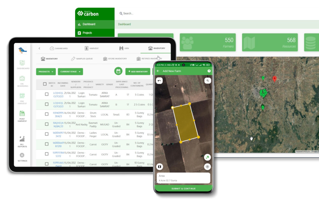
The TraceX EUDR Compliance Platform leverages advanced technologies and data sources to streamline and simplify the deforestation risk assessment process, helping businesses ensure EUDR compliance while minimizing risk.
1. Risk Scoring with Advanced Algorithms
2. Automated Overlays, Alerts, and Validation
3. Integration with DDS Generation Systems
4. Real-Time Risk Assessment and Continuous Monitoring
Deforestation risk assessment is the cornerstone of ensuring EUDR compliance and forms the foundation upon which all other due diligence steps are built. By proactively identifying and mitigating risks, businesses can safeguard against non-compliance, avoid costly penalties, and maintain a transparent, sustainable supply chain. This early assessment not only ensures that the deforestation-free sourcing criteria are met but also builds trust with stakeholders and consumers. In today’s regulatory landscape, taking a proactive approach to deforestation risk assessment is not just a best practice; it’s a strategic necessity for long-term success and sustainability.
Ensure EUDR Compliance with Ease!
Get the insights you need to avoid common pitfalls in geoJSON errors, streamline your Due Diligence Statement (DDS), and leverage satellite monitoring for accurate EUDR compliance.
Explore our latest blogs on:
A deforestation risk assessment under EUDR evaluates the likelihood that the materials in your supply chain come from regions that have experienced deforestation or degradation after December 31, 2020. It uses satellite data, land-use maps, and risk assessment tools to ensure compliance with EU regulations
Key data for the deforestation risk assessment includes geospatial data (e.g., satellite imagery, forest cover maps), legal land use proof, supplier information, and traceability records to ensure that the sourcing complies with EUDR’s deforestation-free and legality standards.
TraceX’s platform integrates geospatial data, satellite monitoring, and real-time traceability to streamline deforestation risk assessments. The platform provides automated alerts, risk scoring, and due diligence documentation, ensuring that your supply chain stays compliant with EUDR while maintaining sustainability and transparency.
