Contact: +91 99725 24322 |
Menu
Menu
Quick summary: Learn how to digitally map your contract farming network for global audits. This step-by-step guide covers geolocation, compliance integration, and tools to enhance traceability and meet international standards like EUDR and Global GAP.

Digital Mapping of Contract Farming enables agribusinesses to track and manage farmer networks with precision, ensuring transparency, traceability, and compliance with global regulations like EUDR and GlobalG.A.P. By integrating GPS coordinates, geospatial tools, and farm-level data into a centralized digital platform, companies can monitor crop activities, validate land use, and prepare audit-ready documentation. This approach streamlines compliance workflows, reduces manual errors, and enhances visibility across the entire supply chain. Ultimately, Digital Mapping of Contract Farming serves as a foundational step toward building resilient, traceable, and globally compliant agri-value chains.
According to FAO, small-scale farmers are often constrained in what they can produce by limited marketing opportunities, which often makes diversification into new crops very difficult. Farmers will not cultivate unless they know they can sell their crop, and traders or processors will not invest in ventures unless they are assured that the required commodities can be consistently produced. Contract farming offers a potential solution to this situation by providing market guarantees to the farmers and assuring supply to the purchasers.
Contract farming, a system where farmers agree to grow specific crops for a buyer, is increasingly vital to global supply chains. However, managing large networks of farmers can be cumbersome, especially when tracking multiple data points across vast regions. Without digital solutions, the risk of inaccuracies and inefficiencies in audits rises, jeopardizing compliance and market access. Digital mapping offers a streamlined, real-time solution to these challenges, enhancing transparency and simplifying the audit process while ensuring regulatory compliance.
Key Takeaways
Discover how innovative geo-mapping technology is transforming the way organic farming practices are tracked, verified, and certified.
Dive into the case study to learn how digital mapping ensures compliance, enhances transparency, and builds trust across the agricultural value chain.
Managing a contract farming network at scale comes with a complex web of challenges that agribusinesses must overcome to remain competitive and compliant in today’s global markets.
Most contract farming ecosystems involve smallholders spread across geographies. Each farmer operates independently, often using paper-based logs or siloed digital systems. This leads to inconsistent, unstructured, and fragmented data across the network—making it nearly impossible to aggregate for analysis, decision-making, or regulatory reporting.
Without a unified data structure, you can’t verify what’s happening on the ground, leading to gaps in traceability and potential non-compliance in global audits.
Procurement teams and agribusiness managers often rely on delayed field reports or manual updates, which don’t reflect real-time crop status, input usage, or harvest schedules. This delay affects planning and operational agility.
Lack of real-time insight means missed procurement windows, overstocking or stockouts, and reactive—not proactive—decision-making.
Regulations like EUDR, FSMA, and other sustainability mandates now demand geolocation, proof of deforestation-free sourcing, and verified due diligence documentation.
Without geo-mapped farms, traceability systems, and standardized records, your supply chain could fail global audits—risking shipment rejections and fines.
Farmer onboarding, training, and support remain manual and scattered. There’s no centralized way to ensure all contract farmers are aware of compliance protocols or data entry formats.
Miscommunication leads to errors in data capture, documentation gaps, and inconsistent adherence to contractual obligations.
Lack of system integration across procurement, logistics, and compliance means multiple teams duplicating efforts, leading to higher operational costs and slower cycle times.
These inefficiencies quietly erode profit margins and make it harder to meet sustainability and transparency targets demanded by global buyers.
With increasing buyer scrutiny, audits can come with little notice. Being audit-ready requires digital traceability, real-time dashboards, and standardized documentation.
Without audit-readiness, even ethically and sustainably produced goods risk being rejected due to paperwork issues or unverifiable data.
The challenges are real—but the solution is digital. Investing in a unified, AI-powered farm management and traceability platform isn’t just about compliance. It’s about building a future-ready, profitable, and sustainable contract farming model.
Explore our latest blogs on the real-world hurdles agribusinesses face in managing contract farming networks — and how farm management software is driving sustainable, scalable solutions.
Learn how to digitize operations, ensure traceability, and empower farmers with data-driven tools.
Read Now:
Farm Management for Sustainable Agriculture
Discover the Top Challenges in Contract Farming & How to Solve Them
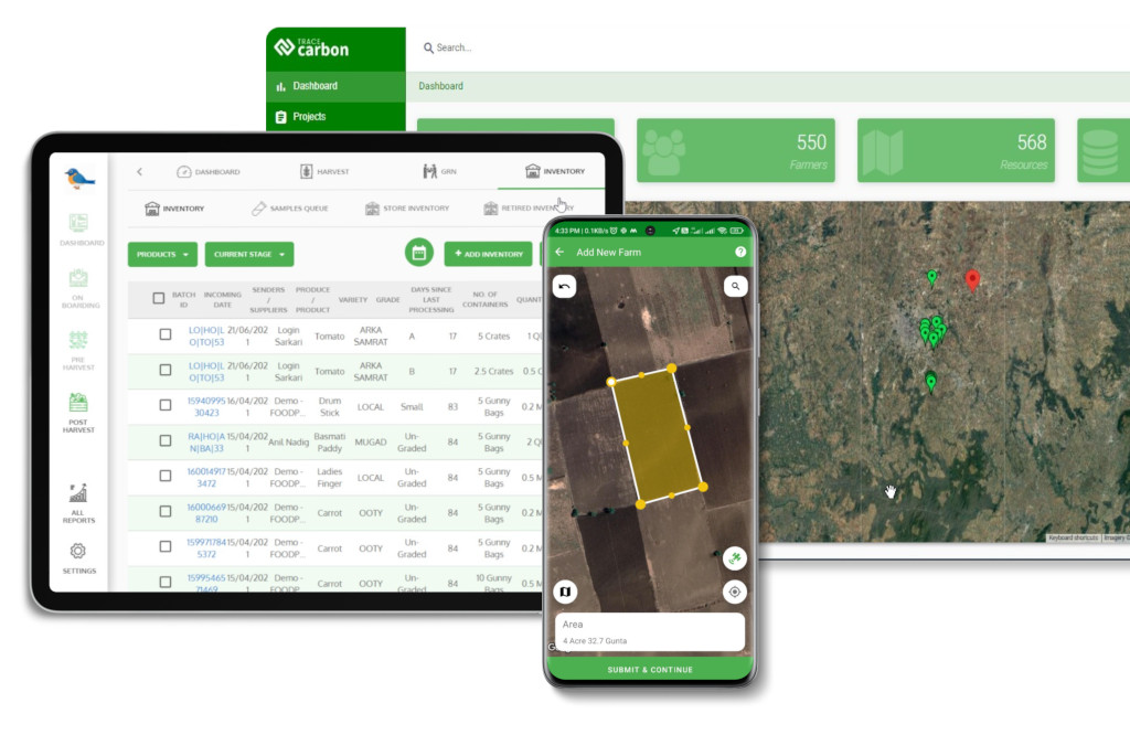
At its core, digital mapping is the process of integrating farm-level geospatial data—such as GPS coordinates, plot boundaries, crop activities, and land use history—into a centralized digital system. It uses tools like GeoJSON, polygon mapping, and satellite imagery to accurately map farm plots and link them to key operational and compliance data.

Unlike manual spreadsheets or fragmented records, digital maps serve as a living layer of truth for your supply chain—one that updates in real-time and aligns with regulatory standards.
With growing pressure for traceability and compliance (especially with regulations like EUDR and FSMA), digital mapping has moved from a “nice to have” to a compliance necessity.
Key enablers include:
These tools help eliminate ambiguity around origin, land status, and production practices—key concerns for buyers and regulators.
In today’s market, traceability is no longer optional. Buyers want proof. Regulators want evidence. And consumers want clean sourcing.
Digital mapping is your foundational layer for:
Many companies focus on just digitizing documentation. But real transformation happens when location, activity, and compliance data are connected—digitally and spatially.
Digital mapping is not just about drawing boundaries on a map—it’s about building a living, auditable blueprint of your entire supply chain. From the ground realities of fragmented plots to the boardroom need for compliance visibility, this step-by-step guide offers an actionable path to resilient and transparent contract farming operations.
Start with comprehensive farm data collection: farmer identities, plot sizes, crop types, soil health, and historical yield. Whether you’re working with thousands of smallholder farmers or larger growers, capturing farm-level granularity is critical.
Use GPS devices, mobile apps, or drones to map the exact geolocation of each farm plot. Export this data as GeoJSON or shapefiles—standard formats required for audits like EUDR, FSMA, or buyer certifications.
Link real-time farm activity data (like sowing dates, input use, pest control, and harvesting) with compliance records such as land titles, farmer contracts, and sustainability certifications.

Break silos by ensuring controlled access to live data for stakeholders—procurement teams, certification bodies, regulators, buyers, and even the farmers themselves.
Once digitized, build automation layers that do the heavy lifting:
Digital mapping is transforming the way agribusinesses prepare for and pass global audits. Instead of scrambling to assemble scattered records and on-paper plot maps, organizations with digital traceability infrastructure can offer on-demand, verifiable, and GPS-anchored data—building confidence with auditors and ensuring faster approvals.

Digital mapping centralizes all plot-level data into standardized, georeferenced formats (e.g., GeoJSON, KML) that can be directly exported and shared with auditors, buyers, or regulators. Platforms like TraceX provide role-based dashboards where external auditors can access only what they need—eliminating the back-and-forth and document overload.
Instead of traveling to remote fields, auditors can now verify farm locations, activities, and compliance records remotely—thanks to geo-tagged images, timestamped crop events, and digital documents stored per farmer or plot.
For global audits like EUDR or Global GAP, remote verification cuts audit time and cost by up to 50%, improving turnaround and reducing risks.
Certifications increasingly demand proof of origin, sustainability, and social compliance. Digital mapping links each batch of produce back to a specific, validated plot—making it easy to:
Unlike traditional paper-based methods, digital mapping is dynamic and continuously updated. As new farmers are onboarded, new crops planted, or new regulations emerge, the system evolves—so your audit preparedness is never out of date.
The Green Earth Fresh Produce (GEFP) case study highlights how a forward-thinking contract farming company in the Nilgiris is using digital traceability technology to build a safer, more efficient, and transparent fresh produce supply chain.
Ajith Pai, Founder and CEO, Green Earth Fresh Produce, says, “TraceX has been critical in helping us to accomplish comprehensive traceability across our supply chain and effectively monitor the inputs and practices in our farms which helps us in ensuring adherence to good agricultural practices that are so important in the minds of our consumers.”
GEFP works directly with smallholder farmers to cultivate Iceberg lettuce, a sensitive crop that requires high standards in hygiene, quality, and timely delivery. Their produce is supplied to Vista Processed Foods Pvt. Ltd, a key vendor for global food chains like McDonald’s and KFC in India.
For Green Earth, the stakes are high:
GEFP adopted TraceX’s farm-to-fork traceability platform, which offered:
This partnership shows how technology adoption in fresh produce contract farming isn’t just about compliance—it’s a competitive advantage for suppliers looking to serve global brands and meet consumer expectations.
Digital mapping isn’t just a tool—it’s the backbone of a resilient, transparent, and audit-ready contract farming network. By capturing accurate farm-level data, integrating compliance workflows, and enabling real-time monitoring, agribusinesses can stay ahead of tightening global regulations like EUDR, Global GAP, and Fair Trade. In today’s agriculture landscape, where traceability and compliance are critical, investing in geospatial mapping and digital infrastructure ensures your farming network remains competitive, credible, and future-ready.
Explore Smarter Farming with GIS & Farm Management!
Dive into our expert blogs covering:
• A complete Guide to Farm Management
• The role of GIS in Agriculture
• Solutions tailored for Smallholder Farmers
Start Reading Now and discover how digital tools are shaping the future of sustainable farming!
Digital mapping ensures precise geolocation of farms, streamlines compliance, and enables traceable documentation needed for global certifications and audits.
Tools like GPS, GeoJSON, satellite imagery, and farm management software help capture, validate, and integrate farm-level data for audit readiness.
It centralizes data, ensures real-time visibility, and automatically links farmers, plots, and practices with regulatory checklists—minimizing errors and compliance gaps.
