Quick summary: Explore how polygon mapping supports climate action by providing accurate tracking, measurement, and reporting for carbon projects, EUDR compliance, and environmental sustainability efforts.
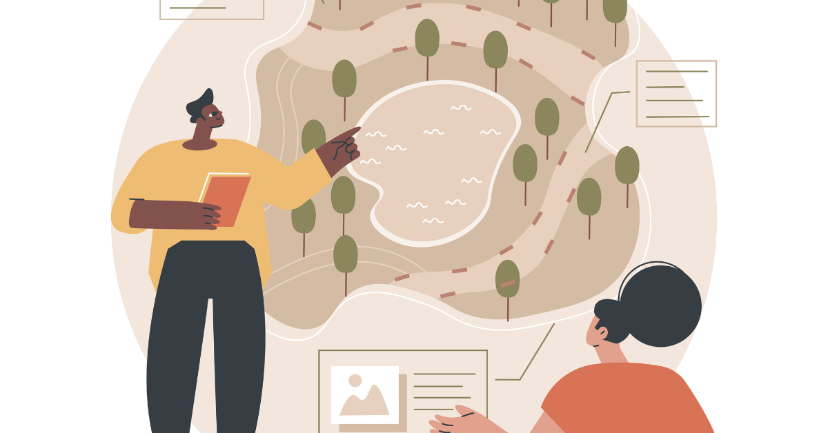
In the fight against climate change, accurate data and transparency are key to developing and executing effective solutions. When it comes to tackling environmental challenges, especially those linked to climate change, having reliable and accurate data is essential. But it’s not just about collecting numbers—it’s about making sense of them in ways that drive action. This is where polygon mapping comes in. By using technology to map out land areas and monitor environmental changes, polygon mapping is revolutionizing how we track, measure, and report the impacts of climate-related activities.
Polygon mapping is a powerful tool in climate action, especially in the context of environmental impact monitoring and reporting. At its core, polygon mapping uses geographical boundaries, often marked by polygons, to define areas on the earth’s surface. With the increasing focus on sustainability, accurate monitoring and reporting are crucial. Polygon mapping plays a pivotal role in this process, especially when it comes to carbon projects, EUDR (EU Deforestation Regulation) compliance, and sustainability efforts across various industries
Key Takeaways
Polygon mapping, at its core, is a geospatial technology harnessed for the creation of precise and detailed maps of specific geographic areas. These areas are delineated using GPS coordinates, giving birth to a digital representation of land boundaries known as polygons. These polygons, visual representations of land areas, serve as an invaluable tool for various purposes, including supply chain management.
How It Works
The process of polygon mapping unfolds through several key stages. It begins with the collection of data, particularly satellite imagery, which provides critical insights into the state of the land in question. The next step involves the analysis of these images, merging them with GPS coordinates to create accurate polygon boundaries. This mapping, which is often facilitated through geographic information systems (GIS), offers a visual overview of the land, making it more accessible for monitoring and management.
Polygon mapping draws its strength from the convergence of various data sources and components. Some of the pivotal elements that underpin this technology include:
The EU Deforestation Regulation (EUDR) is a significant piece of legislation that requires businesses to ensure that the products they import into the European Union do not contribute to deforestation. Specifically, it targets high-risk commodities like palm oil, cocoa, coffee, soy, rubber, and timber, ensuring that these products are sourced from supply chains that are deforestation-free. Businesses must provide traceability for these commodities to demonstrate that they are not linked to deforestation, in line with the EU’s broader environmental goals of promoting sustainable sourcing.
Polygon mapping plays a crucial role in ensuring compliance with the EUDR by providing businesses with the tools needed to track deforestation risks in their supply chains accurately. By mapping specific areas of land using polygons, companies can monitor land use and detect any potential deforestation or land degradation over time. Polygon mapping leverages technologies like Geographic Information Systems (GIS) and satellite imagery to define precise geographical boundaries, allowing businesses to assess the environmental impact of their supply chain activities in real-time.
Through polygon mapping, companies can pinpoint areas of land at risk of deforestation, track changes in land use, and verify whether any of the land they source from is involved in illegal deforestation activities. By using these tools, companies gain deeper insights into the origins of their raw materials and can ensure that they are sourcing products from sustainable, deforestation-free areas.
Example:
For example, polygon mapping can be used to identify specific areas of land where illegal deforestation is occurring, such as a forest being cleared for agricultural purposes. By linking this data with the company’s supply chain records, businesses can verify whether their products are linked to these regions and take necessary actions to source from more sustainable, legal alternatives. This process not only helps meet the compliance requirements of the EUDR but also builds trust with consumers by providing transparency in the supply chain.
In adherence to the updated EUDR regulations, businesses are mandated to achieve traceability down to the farm level, encompassing geolocation data. Geolocation data entails the location of an object determined by latitude and longitude coordinates. For farms smaller than four hectares, companies are required to furnish GPS data, while for larger farms exceeding four hectares, polygon mapping is necessary. Polygon mapping involves delineating the entire perimeter of a farm, contrasting with the provision of a single GPS coordinate.
Ensuring traceability to the specific plot of land, as mandated by the EUDR requirement to collect geographic coordinates, is crucial to demonstrate the absence of deforestation in a particular location. Various methods, including remotely sensed information like satellite images or field photographs with geotags and time stamps, can be employed for verification. The geolocation coordinates are integral to due diligence statements that operators must submit before placing products on the market or exporting them, as per the Regulation. Collecting these coordinates can be facilitated through mobile phones and freely available digital applications, such as Geographic Information Systems (GIS). The precision requirements for geolocation vary based on plot size, with polygons or single points specified for different scenarios.
Carbon projects, such as carbon sequestration and reforestation, play a pivotal role in mitigating climate change by capturing and storing carbon dioxide (CO2) from the atmosphere. These projects aim to reduce the overall concentration of greenhouse gases, either by planting trees to absorb CO2 (reforestation) or by enhancing soil health and forest management practices that naturally capture carbon (carbon sequestration). They are critical in offsetting emissions from industries that are difficult to decarbonize, such as aviation, agriculture, and manufacturing.
Polygon mapping enhances the accuracy of carbon projects by providing precise geographical boundaries for the areas involved in carbon sequestration or reforestation. By using tools like Geographic Information Systems (GIS) and satellite imagery, polygon mapping allows project developers to define exact plots of land where carbon capture activities are taking place. This spatial precision helps ensure that the carbon offset credits being generated are tied to specific, verifiable locations, which is essential for transparency and accountability.
Without clear mapping, there could be uncertainties about the amount of carbon being sequestered or whether the area involved in a project has been properly accounted for. Polygon mapping removes this ambiguity, offering a clear, traceable representation of the land and allowing for accurate data collection on carbon sequestration rates.
One of the most critical aspects of any carbon project is verifying the amount of carbon that has been successfully sequestered over time. Polygon mapping plays a crucial role in this process by tracking changes in carbon stocks within mapped areas. By continuously monitoring the same areas using satellite technology and field data, project developers can track how much carbon is being absorbed by the soil or trees and make necessary adjustments to project practices if needed.
This verification process ensures that the carbon credits being issued for a project are legitimate and backed by real data. For example, if a reforestation project claims to sequester a certain amount of carbon, polygon mapping enables verification by comparing pre- and post-project carbon stocks, ensuring that the carbon credits represent actual, measurable environmental benefits.
Challenges in sustainability and environmental measurement are growing, driven by the increasing need for accurate, transparent, and verifiable data on ecological impacts. As businesses, governments, and organizations strive to meet sustainability goals and comply with regulations like the EU Deforestation Regulation (EUDR) or carbon offsetting commitments, the accuracy of environmental data becomes a major challenge. Polygon mapping is emerging as a vital solution to address these issues, enabling more precise tracking and monitoring.

Now that we’ve explored the benefits and challenges of polygon mapping, let’s delve into the nitty-gritty of how businesses can effectively implement this technology in their supply chains.
The journey to adopting polygon mapping commences with a steadfast commitment to responsible sourcing and sustainability. Companies need to invest in the requisite technology, which includes GIS software and access to high-resolution satellite imagery. Collaboration with experts in geospatial technology can also prove instrumental in ensuring accurate mapping.
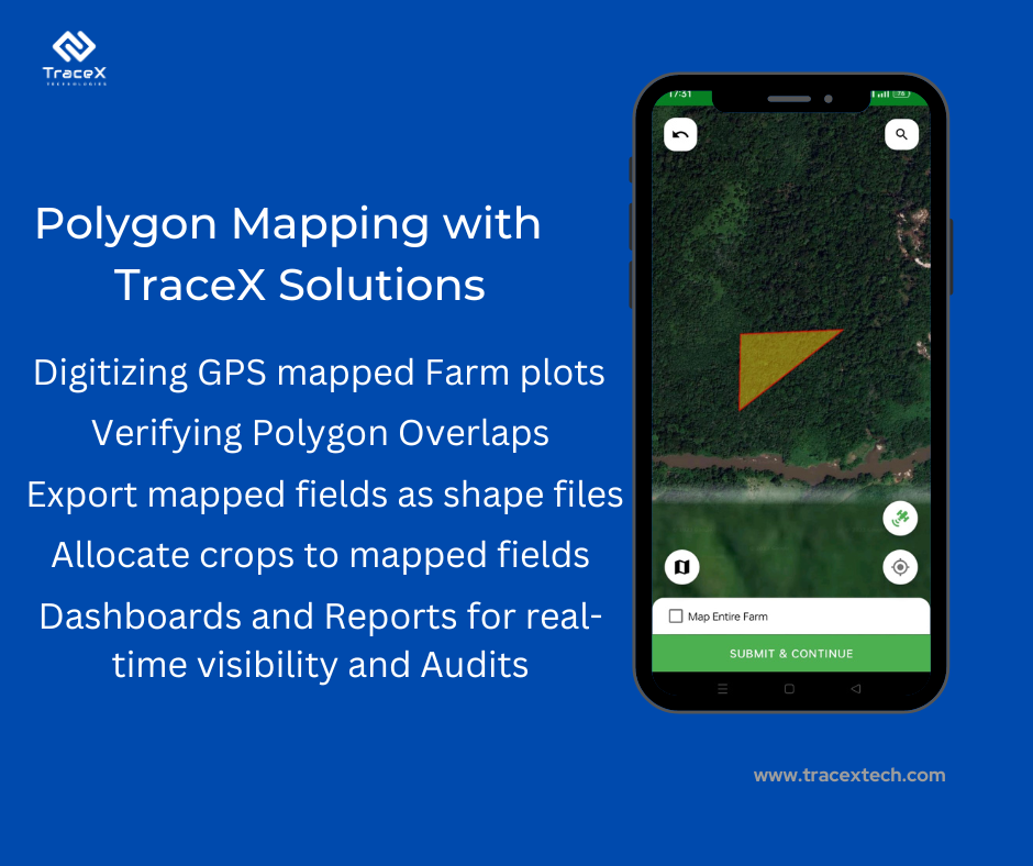
A Nigerian trading company used the polygon mapping feature of TraceX to ensure compliance with the EU Deforestation Regulation (EUDR). By leveraging GPS technology, the company accurately mapped farm boundaries to monitor risks associated with deforestation. The feature flagged areas near protected zones, enabling proactive and responsible land management. It also simplified the mapping process for field officers, ensuring precise boundary delineation and reducing errors, thereby aligning operations with EUDR’s sustainability and traceability standards.
The TraceX polygon mapping feature supports both EUDR compliance and carbon offset projects by providing precise and transparent geospatial monitoring of land use:
For EUDR Compliance:
For Carbon Offset Projects:
TraceX’s technology bridges compliance and sustainability goals by integrating polygon mapping with traceability for effective climate action and supply chain integrity.
The option to restrict overlapping of farm plots is designed to improve the accuracy of land mapping. By preventing field staff from mapping the same area multiple times, this feature reduces the risk of errors, such as duplicating land boundaries or misrepresenting farm sizes. It ensures that each farm plot is clearly delineated, enhancing data integrity and making it easier to track specific areas for traceability and compliance.

This feature is particularly beneficial for organizations working on sustainability projects, carbon farming, or EUDR compliance, as accurate land mapping is essential for reporting and verifying environmental impact. With this restriction in place, field staff can be confident that they are only mapping unique plots, minimizing confusion and streamlining the mapping process.
By incorporating farmers’ plot data into the geo-mapping feature, TraceX ensures that the entire supply chain, from individual plots to larger farms, is accurately represented. This not only meets EUDR compliance but also fosters a more comprehensive and trustworthy approach to supply chain traceability.
In the pursuit of meaningful climate action, the accuracy and transparency of environmental data are essential. Polygon mapping has emerged as a powerful tool, providing precise geographical data that enhances traceability, measurement, and reporting for climate-related projects. Whether it’s tracking carbon sequestration, ensuring compliance with regulations like the EU Deforestation Regulation (EUDR), or monitoring land use changes for sustainability initiatives, polygon mapping helps address critical challenges. It offers clarity, accuracy, and accountability, making it easier for organizations to meet sustainability goals and regulatory requirements while building consumer trust. In the fight against climate change, polygon mapping is not just a tool—it’s an essential enabler of transparency and effective action.
Polygon mapping is a geographical method used to define specific areas for monitoring environmental activities such as carbon sequestration or deforestation. It helps track changes over time, ensuring accurate reporting and accountability in climate-related initiatives.
Polygon mapping plays a crucial role in ensuring that businesses meet the EU Deforestation Regulation (EUDR) requirements by offering precise tracking of land use and deforestation activities. This transparency supports sustainable sourcing and deforestation-free supply chains.
For carbon projects, polygon mapping enables accurate tracking of land areas involved in sequestration or reforestation efforts. This ensures that carbon offset credits are measured accurately and that the process is verified over time, contributing to effective climate mitigation strategies.